Landscape
Timanfaya National Park
Tour a landscape formed by historic eruptions, where underground heat still turns water into steam
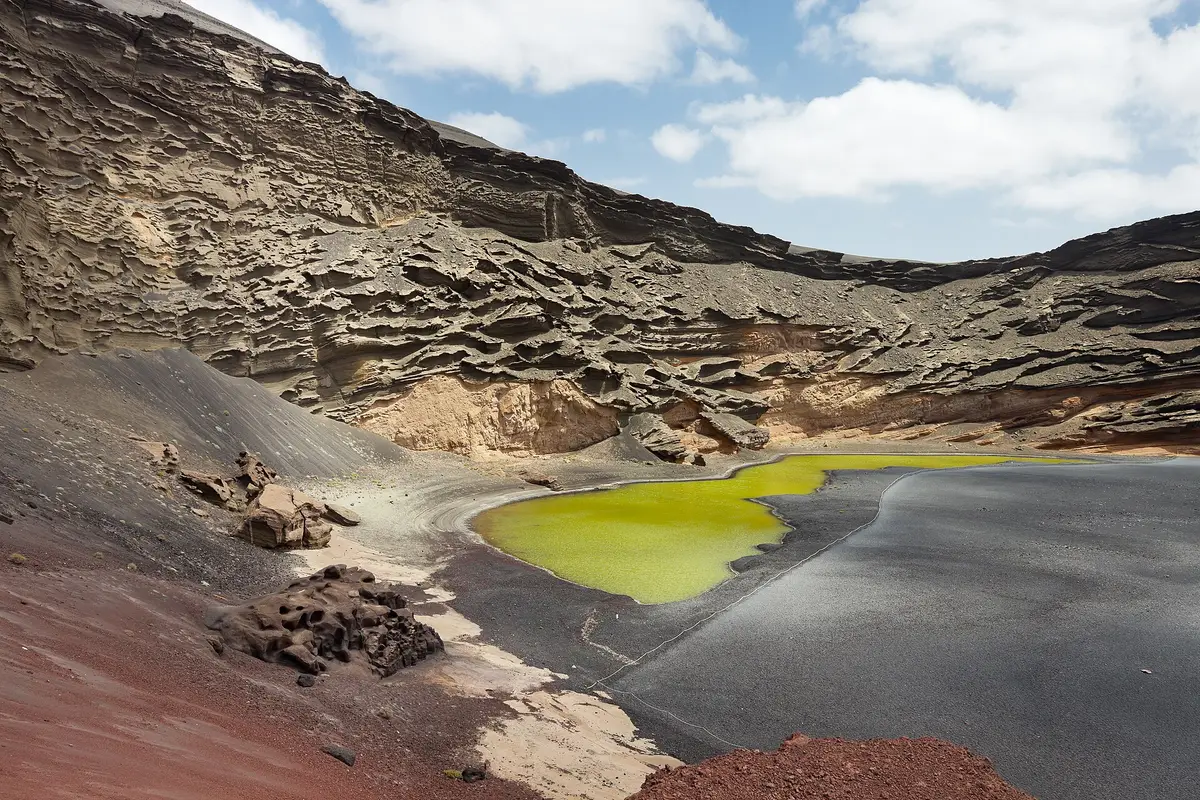
Behind the black shore at El Golfo, Charco Verde forms a green strip of water beneath the remains of a volcanic crater. This coastal lagoon in the municipality of Yaiza is a place for looking rather than swimming: a short footpath leads to a viewpoint, while descent to the beach is prohibited.
Planning a whole day from a base nearby? See things to do in Playa Blanca.
Charco Verde runs parallel to the sea for approximately 100 m, with a black shore on its western side and the raised remains of a volcanic crater to the east. The crater last erupted in the eighteenth century. Seen together, the green water, dark beach and crater wall give the viewpoint its distinctive contrasts, with the sea beyond the strip of shore.
The lagoon is connected to the sea through underground seepage rather than an open channel across the beach. Its green colour is associated with aquatic growth, including Ruppia maritima, and sulphur in the water. The black sand also contains olivine, though the beach is not accessible for a closer look.
The alternative name, Charco de los Clicos, recalls edible bivalves once known locally as clicos. Charco Verde refers instead to the colour of the water. The lagoon belongs to the protected volcanic landscape surrounding Timanfaya National Park, but its defining feature is the meeting of crater, enclosed water and coast rather than an expanse of volcanic terrain alone.
Access is through the small coastal village of El Golfo. From the parking area, a short footpath leads to the viewpoint on the northern side of the lagoon, approximately 50 m away. The approach is on foot; the viewpoint is where visitors look across the water, the black shore and the crater behind it.
Descent to the beach is completely prohibited. That restriction matters when planning the stop: this is not a beach visit with an optional lookout, but a walk to see a protected coastal feature from above. The shore below is a mixture of black sand and gravel, approximately 320 m long and averaging 30 m wide. There is no seafront promenade along it.
Strong marine currents affect this stretch of coast, adding a separate reason not to treat the sea below as a swimming spot. A visit centres on the path and viewpoint, followed by the return towards El Golfo. The short distance from parking should not be taken as confirmation of step-free access.
The lagoon has served as a film location, its green water and volcanic surroundings providing a setting for productions made decades apart. Hace un millón de años, released in 1966, was directed by Don Chaffey and starred Raquel Welch. Enemigo mío followed in 1985, directed by Wolfgang Petersen and featuring Dennis Quaid. Pedro Almodóvar later used the location for Los abrazos rotos, released in 2009 and starring Penélope Cruz.
For a visitor, the relevant sight is the landscape itself: the lagoon beside the dark shore, backed by the remains of the crater. The public approach still leads to the northern viewpoint rather than down onto the beach. Its use as a filming location does not change the prohibition on descending to the shore.
The films add another layer of interest to a stop here, particularly for anyone familiar with their outdoor scenes. The lagoon, crater and coastline remain the concrete features to look at, rather than a separate film attraction or exhibition.
El Golfo and Charco Verde work as a focused nature stop rather than a place to spend time on the sand. The village provides the approach, the footpath supplies the final stretch, and the northern viewpoint brings the lagoon, crater and shore into the same view. There is no need to plan a descent to appreciate the layout; descent is prohibited in any case.
The lagoon lies within the volcanic landscape around Timanfaya National Park, so the connection between them is geological rather than a shared visitor entrance. Here, the coast is central to what you see. Seawater reaches the lagoon through underground seepage, while the black shore separates its green surface from the open sea.
Salinas de Janubio is another named coastal attraction to consider when arranging a day in this part of Lanzarote. Keep the El Golfo stop centred on its own features, however: the crater wall, the enclosed lagoon and the restricted shore below the viewpoint.
_-.jpg)

No - Charco Verde is a viewpoint visit, not a swimming stop, and descent to the beach is prohibited. Strong marine currents also affect the adjoining coast. The permitted visit follows the short footpath from El Golfo to the northern viewpoint, where you can see the lagoon, shore and crater from above.
The green colour is associated with aquatic growth, including Ruppia maritima, and sulphur in the lagoon’s water. Charco Verde takes its name from that colour. Despite being separated from the open sea by the black shore, the lagoon remains connected to it through underground seepage.
The viewpoint is approximately 50 m from the parking area, reached by a short footpath through El Golfo. It stands on the northern side of the lagoon. Access involves walking, and the short distance alone does not establish step-free suitability. The route is to the viewpoint, not down to the beach.
Yes - Charco de los Clicos and Charco Verde are names for the same coastal lagoon beside El Golfo. The name Charco Verde refers to its green water. Clicos was the local name for edible bivalves associated with the lagoon, giving the place its alternative name.
Keep going
Tour a landscape formed by historic eruptions, where underground heat still turns water into steam
Human figures, a refugee boat and marine growth turn the seabed into an underwater sculpture gallery
Vines grow in volcanic gravel, sheltered by conical hollows and low dry-stone walls