Landscape
Timanfaya National Park
Tour a landscape formed by historic eruptions, where underground heat still turns water into steam
Tinajo gives its name to both a village and a municipality in western Lanzarote, northwest of Arrecife. The village is the municipality’s main settlement, while the wider territory reaches the northwestern coast. Visitors come to this part of the island for Timanfaya National Park and the chapel at Mancha Blanca.
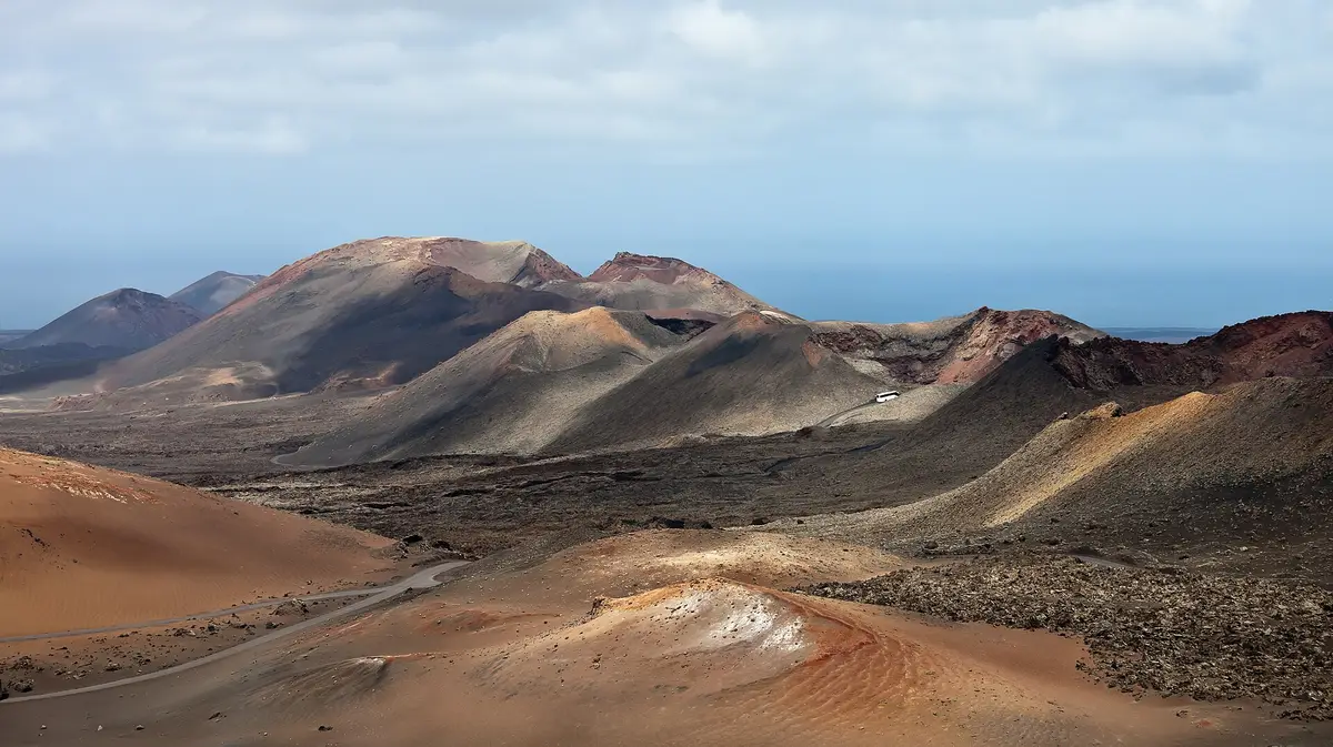
Timanfaya National Park occupies the southwestern part of Tinajo’s municipality. Created in 1974, the park contains most of the municipality’s volcanoes, with rugged ground forming the setting around them. It does not lie entirely within Tinajo: the rest belongs to neighbouring Yaiza. This is the volcanic part of a visit to the area, distinct from the main village and the other settlements within the municipal boundary.
At Mancha Blanca, the focus changes from volcanic terrain to a religious building. The chapel of Our Lady of Dolours, also known as Virgen de los Dolores, is dedicated to Lanzarote’s patron saint. Although it belongs to the municipality of Tinajo, the chapel is in Mancha Blanca rather than the village of Tinajo itself.
The wider municipality also includes El Cuchillo, La Santa and La Vegueta. Together with Mancha Blanca and Tinajo, these settlements fall within a territory covering 135.28 square kilometres. Tinajo is therefore more than the name of a village: it covers a substantial area of western Lanzarote, taking in settlements, the northwestern coast and part of the national park.
Tinajo is the main settlement of the municipality that shares its name. The distinction matters geographically: the municipality extends across western Lanzarote to the northwestern coast, while references to its national park land and chapel concern places beyond the main village. Arrecife lies southeast of the municipality, providing a familiar reference point on the island.
The recorded population of 6119 in 2018 applies to the municipality as a whole, not just the village. Its territory includes El Cuchillo, Mancha Blanca, La Santa and La Vegueta alongside Tinajo. These are separate settlements within the same municipal area, rather than different names for the village centre.
Tinajo’s principal points of interest are consequently spread across that wider territory. The chapel stands in Mancha Blanca, and the volcanoes associated with Timanfaya National Park are concentrated in the southwest. The main village, the religious site and the national park are distinct parts of the area, rather than attractions gathered together in a single village centre.
Tinajo and Yaiza share Timanfaya National Park between their municipal territories. The Tinajo portion lies in the southwest of its municipality, where most of its volcanoes are found; the remainder of the park belongs to Yaiza. The park’s rugged volcanic land therefore crosses a municipal boundary rather than belonging solely to either place.
For Tinajo, the park is part of a wider geographical identity that also includes the northwestern coast and several settlements. Its main village carries the municipal name, while Mancha Blanca contains the chapel dedicated to the island’s patron saint. Those distinctions explain why the name Tinajo can appear in connection with both volcanic scenery and a religious building located elsewhere in the municipality.
The park was created in 1974. Its volcanoes and rugged ground are the concrete features that distinguish this part of Tinajo’s territory from its settled areas. Yaiza is the other municipality associated with that same protected landscape, rather than a separate volcanic attraction competing with it.
The chapel of Our Lady of Dolours stands in Mancha Blanca, within the municipality of Tinajo. Its dedication is to the patron saint of Lanzarote, also known as Virgen de los Dolores. That island-wide religious connection gives the building a significance beyond the settlement in which it stands.
Mancha Blanca is not another name for Tinajo village. It is a separate settlement within the same municipality, alongside El Cuchillo, La Santa and La Vegueta. A visit centred on the chapel therefore belongs to Mancha Blanca, even when the broader destination is described as Tinajo.
The chapel provides a different focus from the municipality’s volcanic terrain. In the southwest, Timanfaya National Park contains most of Tinajo’s volcanoes and extends into Yaiza. At Mancha Blanca, the specific landmark is instead a building dedicated to the island’s patron saint. The chapel and the national park are distinct places within the wider area, not neighbouring features of the village centre.

Tinajo is in western Lanzarote, northwest of the island’s capital, Arrecife. The name refers both to the main village and to the surrounding municipality, which reaches the northwestern coast. Mancha Blanca, El Cuchillo, La Santa and La Vegueta are also settlements within that municipality, rather than parts of Tinajo village.
Part of Timanfaya National Park lies in the southwestern part of Tinajo’s municipality; the rest is in Yaiza. Established in 1974, the park features volcanoes and rugged terrain. Most of the volcanoes within Tinajo’s municipal boundary are in this protected area, rather than in the main village.
The chapel of Our Lady of Dolours is in Mancha Blanca, within Tinajo’s municipality. Its dedication is to Lanzarote’s patron saint, also known as Virgen de los Dolores. The location is separate from Tinajo village, so the chapel and the main settlement are distinct stops within the wider area.
Tinajo is both the main village and the name of its surrounding municipality. The municipality covers 135.28 square kilometres and includes El Cuchillo, Mancha Blanca, La Santa and La Vegueta. Its recorded population of 6119 in 2018 refers to the whole municipal area, not only to Tinajo village.
Keep going
Tour a landscape formed by historic eruptions, where underground heat still turns water into steam
A subterranean salt lake and lava openings form the setting for César Manrique's cultural centre
Enter a drained lava tube with illuminated cave walls and a concert hall near its entrance